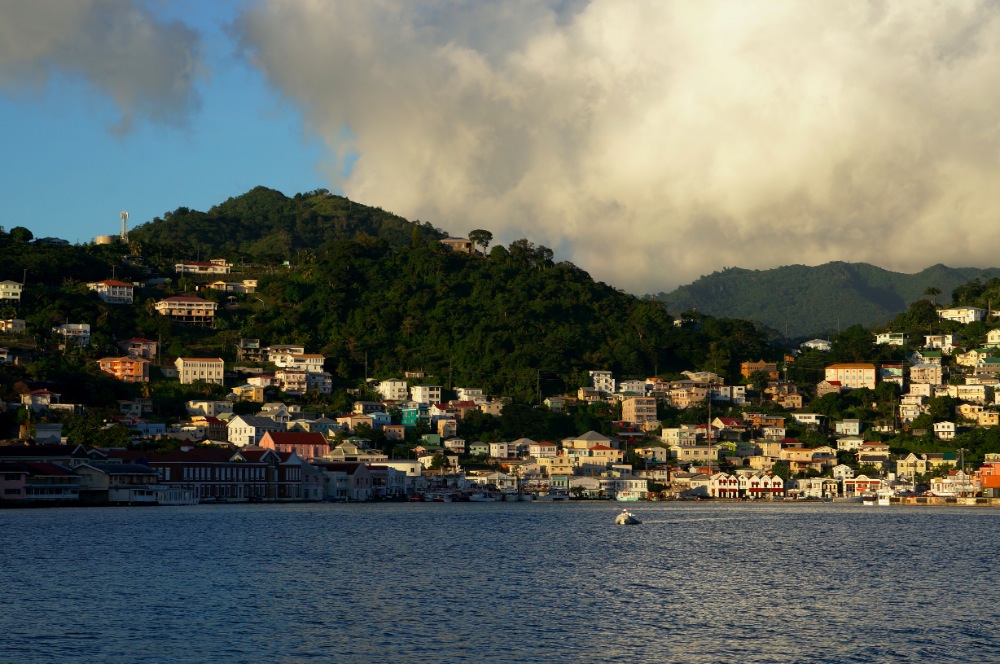
5th of August, Grenada Island, Caribbean Sea.
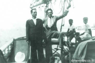
The docks of St-George’s harbour are on turmoil, two schooner ships are about to leave for an expedition upper north, on the island of St Vincent. A large chunk of this English protectorate’s middle class youth is gathered. The cheekier ones exchange their places aboard the Providence Mark to embark aboard the Island Queen were the atmosphere is a little more festive. Why, one would ask ? The prettiest girls of the colony are on board.
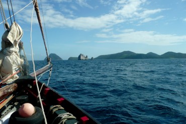
As the Providence Mark is following the coastline, Chicra Salhab, the captain of the Island Queen decides to sail a little further ashore. He proudly steers his ship that contains 67 passengers. The night falls, the Sea is starting to get a little more agitated and the lights of the Island Queen are slowly disappearing. The next morning, the Providence Mark arrives in St-Vincent first. After the custom duties, the passengers seek for their friends on the second schooner who should arrive shortly. But the hours pass and the Island Queen is nowhere to be seen. It will never arrive to its destination.
For several weeks, many planes and ships are gathered to find the missing ship… But it is getting more and more obvious: everything disappeared. Nothing, not even a single remain of the ship were found. Nearly every Grenada family has lost a child in this drama. At the time, the investigators declared that a fire started on board, causing the shipwreck of the Island Queen. A few witnesses declared that they saw some smoke rise from the neighbouring island of Carriacou, but in Grenada, the families were not satisfied with the inquiry’s conclusions and many theories are brought forward. Some think that a German submarine torpedoed the ship. Others think about a collision with a floating mine. A few are however opposed to these theories. Why haven’t they found any remaining parts of the ship in the sea or on the beach? According to Jan Lindsay a volcanologist from the University of West Indies (UWI), based on Trinidad, the disappearing of the Island Queen could have another cause. For him the responsible is approximately 2’300 meters high and peaks at 180 meters under the surface. It’s name: the Kick’em Jenny, the only active underwater volcano known in the Caribbean Sea, located eight kilometres North-West of Grenada.
Under the surface, the earth moves
Imagine an underwater volcano that awakes, grounding. Ready to expel rocks and ashes from the bottom of the sea. It’s in 1939 that Kick’em Jenny is first heard. The inhabitants of North Grenade feel the earth tremble under their feet, two meter high waves smash against the coast of the Grenadine Islands and during 24 hours, a huge 300 meter high pillar of smoke thorns the horizon North-West of the island. Under the sea, Kick’em Jenny is awaking. We understand better why many geologists study the West Indians arc since the 1940’s. The American tectonic plate dives under the Caribbean plate, causing a subduction zone, that is when a tectonic plate passes underneath another plate, creating a chain of volcanoes. In the Caribbean, an underwater volcano created every island. Some are still in activity.
In October 1943, seismographs were installed in Martinique and have recorded sound waves that are typical from explosions or underwater earthquakes. They are called “T-phases”. The following months, the water above Kick’em Jenny is agitated. The volcano seems to be letting large amounts of gas running out, creating clouds of bubbles above it. This phenomenon that usually takes place between two eruptions, creates a drop in the water’s density above the crater, reducing the buoyancy of any object floating above. To simplify, we can affirm that Newton wins over Archimedes: any boat that would sail near the volcanoes waters would be sucked under the water. A few months from the passage of the Island Queen, Jan Lindsay’s hypothesis seems plausible.
Kick’em Jenny’s largest explosion was registered in 1939. Since then, the devices installed by the scientists have identified no less than twelve eruptions. For most of them, they weren’t any exterior signs, no columns of smoke or rock explosions. Only slight tremors were recorded. We should still stay wary of the apparent stillness of the water. Kick’em Jenny’ physiognomy is changing, getting closer and closer from the surface. In a few years or centuries, Kick’em Jenny will emerge, giving birth to a new island, like her Caribbean neighbouring islands.
Frédéric Dondin, volcanologist at the UWI, summarizes: “ Today we have no idea of the volcanoes age, a study is in process. “ On the other hand, we have been following for a few decades the evolution of its progress to the surface. The bathymetric studies have established that between 1962 and 1966 the volcano gained 46 meters, his summit going from 232 meters under the surface to 190 meters. During the late 1980’s, it had reached -150 meters and a dome had formed in the middle of the crater. This phenomenon has been observed from the ground, St-Vincent Island further up north as seen this happen to her. His volcano, “la Souffrière”, was sheltering a 175 meters deep lake at the bottom of its crater. In September 1971, many eruptions gave birth to a lava cork that reached surface in November of the same year. Its height had increased by two to three meters every day until March 1972.
As the dome of “la Souffrière” is still here, Kick’em Jenny’s one collapsed under the power of a series of eruptions.
An unparalleled place
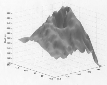
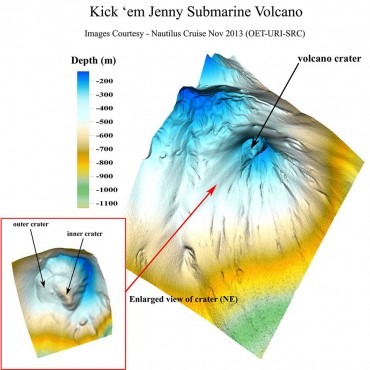
For the UWI, Kick’em Jenny is a unique place, an incredible in situ laboratory, allowing to witness the birth of an island. During March 2003, The UWI partners with the University of Rhodes Island and the National Ocean and Atmosphere Administration (NOAA), an American state agency. A large-scale oceanographic campaign is led from the oceanographic ship Ronald H. Brown. A detailed cartography of Kick’em Jenny’s seafloor is created with a multybeam sounder, a high precision acoustic tool used to represent the underwater landscape. In a few days, the map is getting readable. Kick’em Jenny’ huge crater is measured: It is formed with a nearly perfect circle that is 350 meters wide and 80 meters wide. The slopes are shaped like a horseshoe extending on 20 kilometres for the West part. Many sediments scattered around the volcano can be observed, remains of the collapse of the volcano years ago.
On his screen, the cartographer moves around and spots three other volcanic craters and two cones, one of them shall be named Kick’em Jack. We still need to know if these rocks are from the same nature as the ones found on Kick’em Jenny and if these two craters are sharing the same magma chamber. “The proximity of these two craters leaves us thinking that they are both part of the same volcanic complex created by the submerged volcanoes “l’île de Ronde” and “l’île de Caille” and also the volcanic dome of Diamond Rock”, Frederic Dondin tells us. He also points out that a study is pending to validate this hypothesis.
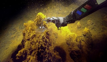
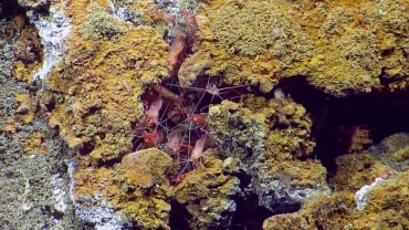
On board the Ronald H. Brown, the excitement is at its peak when the ROV, the ship’s submarine robot is sent out to collect rocks and biological samples. As soon as the machine hits the ground at 260 meters deep, it detects gas and liquids leaking out of the chimney, reaching temperatures as high as 250°C. But strangely, in the middle of this inferno, the robot is able to film life. Among the discoveries, a worm from the Spionida family lives in this peculiar and apparently inhospitable place, hanging to the sides of the volcanic chimney.
Karen Wishner, a biologist from the University of Rhodes Island, can’t believe it: “ There is a specific biological community in the volcano, this is interesting on an international scale because these are the first species found at a low depth in a volcanic chimney”. There is, probably at the heart of Kick’em Jenny, life forms that we cannot observe anywhere else on the planet. But that’s not all: when they climb up the sides of the crater, the ROV finds itself caught by a wall of gas bubbles. Kick’em Jenny emits gas continuously thanks to its conducts located inside the crater. This could confirm volcanologist Jan Lindsay’s theory on the disappearance of the Island Queen!
The Nautilus live
In 2013, the exploration ship E/V Nautilus, led by the famous shipwreck explorer Robert Ballard who explored no less than the Titanic and the Bismarck, sails to the volcano’s location. The purpose of the mission is to study the hydrothermal system of the volcano and the biological communities that have settled there. Thanks to the ROV of the expedition Hercules, the scientists discover a red-orange soil covered with iron oxide produced by the bacteria forming small layers on the ground. A little further, on the slopes of the crater, in the middle of the volcanic sediments, two particular sites catch the attention of the two scientists. They are able to observe new conducts releasing “cold seeps”. Frédéric Dondin now on board the Nautilus explains us: “ these “seeps” are effusions of fluids that are rich in organic matter and methane. They form when sediments are crushed together and are under great pressure, and then they migrate to the surface. Once they are expelled, they are a great source of nutriments for the different organisms living around”. Near these incredible food-safes, a moray eel, a grouper, a few stingrays and even an octopus can be observed. Hercule makes other strange encounters. On his path he crosses many sessile organisms such as anemones, clams, worms or even 35 centimeters long mussels.
“This discovery has been one of the main events of the 2013 mission!” says Frédéric Dondin barely containing his excitement. The “cold seeps” phenomenon was already known. Here, The sessile animals are far from the sunrays. The plants having no access to sunlight underwater have to use the energy created by complex chemical associations naturally present in the water. Some characteristics that are very close to those found in hydrothermal springs. “ According to the team of scientists still on this mission, it’s the first time that “cold seeps” could be observed, described and sampled on an underwater volcanic landscape”, points out the researcher. Never before have cold seepages been recorded on a volcanic debris site. The volcanologists study the possible origins of this phenomenon.
Hercules keeps on his exploration. He had the opportunity to explore the top of the other volcanoes, juxtaposing Kick’em Jenny. Incredible lava spills testify the past eruptions. For the first time, it has been possible to observe underwater pitons, comparable to the submerged ones of the “Petites Antilles”. One of them, located in the crumbled part of Kick’em Jenny’s crater, is a hundred meters tall. The right challenge for any rock-climbing enthusiast! At the summit, deep-sea corals have taken residence. The fascinating landscape and environment creates great curiosity among the researchers that still don’t forget that under this incredibly rich biological world, a beast is asleep.
Even protected by its lid of seawater, Kick’em Jenny volcanic activity is still a great threat. There is of course this continuous degassing flow that can create a loss of floatability for the ships sailing too close; an area of three kilometres wide as been established around the volcano as a non-sailing zone since the place is very frequented. Still, few amateur yachtsmen take this restriction into account. The locals are more aware about the tsunami threat that could be created by an important eruption or a landslide on the slopes of the volcano. Underneath Kick’em Jenny, the magma is stocked in a chamber a few kilometres deep. When these molten rocks start to move, it forces the passage to escape and generates earthquakes. They are usually of low amplitude and they are only identified by the scientists seismographs. When they get more frequent, it’s the sign of a future eruption. The volcano is getting angry. It’s exactly what happened the 4th of December 2001, during the last Kick’em Jenny’s eruption: a series of earthquakes lasted for 24 hours, followed by a small eruption.
Tsunami, code yellow
John Shepherd, head of the seismic research centre of UWI, and one of the first to have studied Kick’em Jenny in 1974 points out that “ when the summit is deep underwater, the weight of the sea diminishes the energy of the explosions, but if it came closer to the surface, these would be much more violent and the Tsunami hazard would be greater”. The rocks analysed from the eruptions of the past 20 years show Kick’em Jenny’s magma contains a lot of dissolved water. The consequence is, that by getting closer to the surface and the pressure diminishing, the water is taking more and more space in the rocks and creates explosions! A phenomenon that the scientists are closely following. Even though “the risk of a tsunami caused by an eruption is low”, tempers Frédéric Rondin. The risk is low but it still exists. In case of a tsunami, the islands concerned are the archipelagos of Grenade and St-Vincent, the Grenadine islands and Barbados. But the effects could be felt in an area that would extend from Puerto Rico to the North coast of Venezuela. “ The research centre is evaluating this tsunami hazard link to the instability of the volcanoes slopes. The scientific article is in preparation at this very precise moment”, points out again the scientist.
Kick’em Jenny is constantly under surveillance. Every day, the scientists “listen” to the volcano, the slightest abnormal wave gives them indications on its state. Seismographs detect the earthquakes, tides gauges measure abnormal changes, hydrophones react to any underwater explosion and tilting meters associated with GPS’s detect changes in the landscape. This technologic deployment is necessary to detect any anomaly that would precede an eruption and give the alert. In 2007, the Kick’em Jenny has even received a new surveillance system: an anchorage equipped with a seismometer, which is attached to a cable going straight to the summit of the underwater volcano, sending instant measures. But what would happen in case of an alert? A huge wave created by the tsunami would arrive on the coast within minutes and it would probably be too late to react. The 26th December Indian Ocean tsunami is a sad example. However, if the area is watched over and the countries at risk are prepared, the tsunami can be managed. On March 2014, 900’000 Chileans living on the North Coast, between Iquique and Arica were evacuated during a tsunami alert, following a seism of magnitude 8.2 on Richter’s scale. The alert was finally retrieved, but the population was able to evacuate on time.
In Grenade, a system of alert has been put in motion. It has recently turn to alert level yellow, which means that the volcano’s activity has raised slightly above its historical level and that the zone is considered as dangerous. The surveillance network is since being used at his maximum capacity, the civilian authorities are alerted and communication systems are verified. Information and prevention campaigns are reinforced among the population and the Safety observatory has to be ready to alert the boats sailing nearby the menaced zone. Frédéric Dondin explains that it’s the nature of the seismic signal that counts: “ two types exist: the volcano-tectonic (VT), that characterize the recovery of a seismic activity, and long term seismic signals (LP). The second ones announce the imminence of an explosion. Today, the signal is green because we register a low level of VT (once per year), and no LP”.
Yellow or green, with an eruption approximately every five years since 1939 and non-activity periods that didn’t exceed twelve years, volcanologists are keeping their ears open. The last eruption occurred 14 years ago, in 2001. For Richard Robertson, a researcher from the seismic centre, the network of instruments is fundamental, but it is equally essential to strengthen information and communication with the locals, in order to make them able to know what to do in case of an alert. They have to be able of spotting and interpreting early signs of a tsunami and reach the heights as soon as possible. For those at sea, sail to the open sea… And brace yourselves!
On the island there are still many makeshifts houses, made of corrugated iron and wood. They wouldn’t resist a major catastrophe. As so, in 2004, hurricane Ivan killed 23 people and destroyed 90% of the island’s habitations. Since then, many houses have been rebuilt. The damage from a tsunami would probably be as devastating. At Carriacou, in 2005, following the tsunami that hit the Indian Ocean, they were many awareness meetings. In Lesterre’s part of town, situated South-West of the island, the school walls have this sign on it: “Since school, we prepare you against natural catastrophes”. Posters of the West Indies University informing about Kick’em Jenny or the reaction to have in case of a tsunami are scattered around. Frédéric Dondin shares Richard Robertson’s point of view: “A major problem on the island and probably also in the French West Indies is that risk management for tsunamis are at their early stages”.
On these paradise-like islands, locals have learned to live with Kick’em Jenny and life follows its peaceful course. At Hillsborough’s information stand, in Carriacou, the staff doesn’t seem to be aware of a bus transportation system or any device that could bring the habitants quickly to the heights of the island. A lot share Mary’s opinion, a young custom official who is a little fatalist: “Yes, Kick’em Jenny is dangerous, but Carriacou is a blessed island, and thanks to god we are safe”. For sure, only drums like steelbands or djembes are making the walls tremble. For now.
